LiDAR is a form of surveying that measures distance using laser pulses. LiDAR data is used for mapping purposes in many different fields, from civil engineering to land development.
LiDAR mapping technology helps you to capture information, process the data, and create detailed maps.
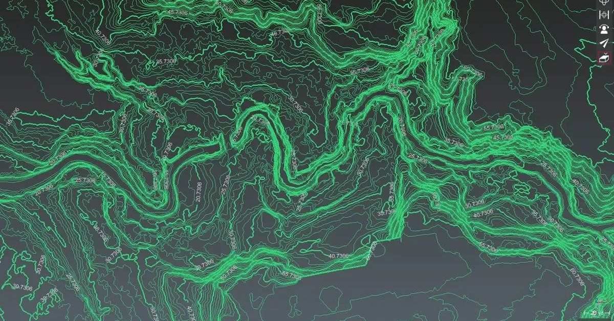
A LiDAR system collects 3D measurements of various areas and creates digital elevation models and digital terrain models, which are widely used in surveying tasks.
To understand how it works, let’s look at a few examples. LiDAR mapping uses narrow laser beams that are able to pass through trees to collect data on the ground below. This technology allows cartographers to map both the forest floor and treetops and obtain extremely accurate height measurements of trees.
Previous methods, such as photogrammetry, required cartographers to study aerial photographs to determine tree height. But LiDAR mapping technology records tree dimensions 100 times more accurately.
LiDAR mapping is not only used by businesses, but also by government agencies to accurately create 3D maps of different areas on Earth. This technology can help you to easily map ground surface, underwater terrain as well as outer space sites.
Who Invented LiDAR Mapping?
The initial concept of LiDAR dates back to the 1930s, even before the invention of the laser. EH Synge conducted an experiment in which he tried to measure the composition of the atmosphere. He used sweeping searchlight beams instead of a laser.
However, the first LiDAR-like system was invented in 1961 by Hughes Aircraft Company after the invention of laser technology in 1960. The system used laser-focused imaging along with data acquisition electronics and appropriate sensors to calculate the distances. It was known as CoLiDAR and was developed for satellite tracking.
In 1962, LiDAR technology was used to measure the distance between Earth and Moon. Then in the year 1965, the first laser-radar LiDAR system was patented by Ronald Collins. However, it wasn’t until 1971 that LiDAR was used for mapping applications.
LiDAR mapping was used for the first time in 1971 by Apollo 15 astronauts to map the moon’s surface. Since then, LiDAR has been used for everything from monitoring populations to mapping underwater terrain.
While there is no single person credited with the invention of LiDAR, the technology did emerge in the early 1960s alongside the widespread use of lasers.
How Does LiDAR Mapping Work?
The goal of LiDAR mapping is to generate maps in which the XYZ coordinates of the targeted reflective surface are extremely accurate. This technology has many advantages over other methods of mapping, including increased vertical accuracy, higher efficiency, and versatility in a variety of environmental conditions.
LiDAR mapping uses laser emission technology, in combination with scanning and control mechanics and a global positioning system or inertial measurement unit to produce detailed terrain models. With this technology, aerial photography is transformed into a high-resolution map that features buildings, streets, and other features in a close-to-perfect manner.
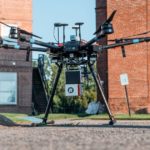
For LiDAR mapping, you not only need a LiDAR sensor or scanner but an entire mapping system. It consists of a LiDAR system, GPS receiver, and Inertial Navigation System (INS). The mapping system can be mounted on drones, aerial crafts, land survey vehicles, tripods, or other applications.
To make a 3D model of an object, a LiDAR sensor pulses laser beams towards an object or an area. To produce high-quality LiDAR maps, modern systems can emit up to 100,000 pulses per second. These pulses are short enough to penetrate vegetation and model the ground beneath buildings and trees. Modern systems consist of a laser source and a spinning mirror that projects the laser beam onto the Earth’s surface.
After emitting laser beams, the receiver mounted on the system captures the return pulse. The laser energy reflected off the object reveals its surface composition and texture. The receiver also uses the speed of light and the time it takes for the pulse to return to calculate the distance of the object.
The receiver collects all the data regarding the distance and shape of the objects in the area. This data is then processed, filtered, and stored in a database. The software helps to process the LiDAR scans and data to create a map. The IMU system is then used to improve the quality and accuracy of the map. This is how a LiDAR mapping system works.
LiDAR data is used for a variety of purposes, including mapping the terrain and generating high-resolution elevation datasets. LiDAR maps contain information on distance, elevation, and surface composition.
How Much Does LiDAR Mapping Cost?
The cost of LiDAR mapping depends on the type of LiDAR system you are using and the size of the project. For instance, terrestrial LiDAR mapping is cheaper than aerial mapping. LiDAR mapping done using a drone can cost anywhere from $50,000 – $350,000.
The price of the LiDAR mapping solution will depend on the features of the system. You need to factor in the cost of a LiDAR sensor, drone, GPS receiver, Inertial Navigation System (INS), and software or algorithm to process the data and create maps.
However, if you opt for LiDAR mapping done using a land survey vehicle, it will be much cheaper. You don’t have to pay for a drone or a base station.
The cost of LiDAR mapping will also depend on the size of the area you’d like to map. A smaller area can be covered with SfM (structure from motion) from an unmanned aerial vehicle, but in dense vegetation, this method won’t provide ground penetration. Regardless of the method, aerial LiDAR is expensive to fly, so it’s important to check the size of the area you need to map.
What Is LiDAR Mapping Used For?
The use of LiDAR in mapping is becoming increasingly widespread. LiDAR mapping is used to map geological sites, underwater terrain, and even outer space. It’s used by both private companies, as well as government agencies. Here are some of the main applications of LiDAR mapping.
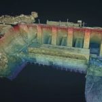
Archaeology
A key tool for archaeologists, LiDAR mapping has been used to detect ancient human ruins, which may be hidden by vegetation. LiDAR has revolutionized the field of archeology, enabling researchers to pinpoint the exact location of objects of importance within ancient sites, and other ancient objects.
Objects found from LiDAR surveys are challenging conventional theories about ancient civilizations. LiDAR mapping combines the expertise of field archaeologists with the precision of LiDAR technology.
Agriculture
The use of LiDAR in agriculture is quickly gaining momentum. This powerful remote sensing tool provides high-resolution spatial information that is crucial for many applications in the realm of agriculture.
Although a farm may just seem like a large section of flat land to the average person, a LiDAR system can detect a lot more. For example, its soil can contain numerous unseen slopes and variations. By mapping the terrain, farmers can determine the best crops to plant in what areas, and apply the appropriate fertilizer.
LiDAR data can also help farmers better plan their farming operations. The use of these maps in agriculture allows farmers to increase their yield and minimize their costs by planning out their farms better.
Astronomy
As mentioned earlier, one of the first uses of LiDAR mapping was in astronomy. The Apollo 15 program used lasers to map the moon. NASA also later used LiDAR mapping to generate an accurate map of Mars, using retroreflectors that reflected lasers from Earth. LiDAR is very accurate in mapping celestial bodies, and in 2001 it was used to produce an incredibly accurate topographic map of Mars.
But the technology has far more applications than mapping celestial bodies. Among the uses for LiDAR mapping, it’s used to study the composition of the stratosphere. High-altitude, thin clouds, like cirrus clouds, can be invisible to conventional remote sensing satellites, but LiDAR can detect them.
Civil Engineering
LiDAR produces accurate, detailed maps of terrain by using precisely measured pulsed laser beams. It is now used by civil engineers to improve design efficiency, facilitate analysis, and make better decisions. LiDAR mapping helps civil engineers plan and build structures, by providing them with detailed maps of terrain that can be analyzed to influence decision making.
It is especially useful in mining, where accurate terrain maps are needed for safe construction. Tunnel construction also requires careful planning and precise measurements, which is where a good LiDAR system comes in handy. Since LiDAR can be used in dark environments, it’s useful for civil engineers that are building structures in a low-light environment, such as a mine.
Geographical Information Systems (GIS)
A geographic information system (GIS) is a tool that builds an inventory of everything on Earth and stores information that is tied to a specific location. This information can include a wide range of data. From people and income, to tracking the different types of vegetation, soil, and even locations of factories.
GIS also enables a user to analyze large amounts of data and display it in an easily understandable graphical form. To compute all this data, geographical information systems use LiDAR mapping technology.
Dimensional Control
Dimensional control is a key component of design and production. In the design process, dimensions are specified, along with fabrication tolerances. Design integrity assurance is driven by the need for an as-built model that demonstrates the deviations between the theoretical model and the actual result.
Redesign or revamp work typically begins with a survey and laser scan of existing conditions. These sets of data are used to create the boundary conditions and tolerances that will be used for the subsequent design. LiDAR mapping is used to scan the existing conditions as well as the dimensions of a product.
High-Definition Surveys
LiDAR is a modern method of high-resolution 3D scanning. Its lasers sweep across terrain or building to gather millions of data points. With such a large number of data points, a LiDAR system can produce extremely precise 3D measurements and maps.
You can use LiDAR technology to create high-definition 3D maps, which are essential for high-definition surveys. In addition to faster and safer data collection, these maps produce highly-accurate imagery. This is important for companies and governments since the accuracy and timeliness of survey data can impact a project’s bottom line.
Pipeline Mapping
A relatively new use for LiDAR is in the pipeline industry. It can be used in a new airborne remote sensing technology that uses differential LiDAR to detect leaks associated with pipelines. It combines a digital camera and a global positioning system to map pipelines.
The system has several objectives, including increasing the accuracy of the detection system and reducing false-positive detections.
LiDAR technology has many applications in the pipeline industry, from estimating the length of buried pipelines to assisting in the accurate placement of hundreds of pipe welds. Since LiDAR is so accurate, it’s perfect for the mapping of large-scale pipeline networks.
Climate Change
LiDAR mapping allows scientists to make more informed decisions about the placement of carbon offsets based on the amount of carbon that different types of vegetation can store. They can also monitor the effects of climate change on land availability.
The use of LiDAR in climate change research is already helping scientists understand the impact of climate change. In addition to identifying the causes of climate change, LiDAR allows scientists to monitor the effects of human activities on the atmosphere. By examining atmospheric composition, LiDAR can help researchers forecast climate change.
Flood Mapping
LiDAR-derived digital surface models (DSMs) are highly accurate for determining the topography of large areas. They can be used to develop flood maps and flood hazard assessments.
LiDAR has been used extensively in the environmental sciences world, particularly in the environmental monitoring and flood hazard analysis fields. Flood mapping using LiDAR is a low-cost, easy method for flood estimation. It integrates a large portion of flood parameters into one system.
The results of the method can be used to evaluate flood risks in any area. The methodology used to determine the flood risk levels of individual properties and cities can be used to control land use in floodplains.
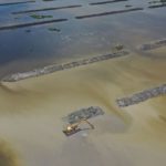
Coastal Environmental Mapping
Another use for LiDAR is in coastal environment mapping. Its high sensing frequency makes it able to cover large areas relatively quickly. In topographic and hydrographic modes, coverage rates of up to 20 km2 per hour can be achieved. This is essential for coastal mapping since there is very often a large area that needs to be covered.
The data obtained by LiDAR also provides tidal zone coverage, which is critical during short tide windows. Airborne LiDAR surveys can provide a more precise representation of large-scale coastal behavior.
LiDAR data also reveals features that are not visible with coarse-resolution DEMs (digital elevation models, we will go over these in a bit). Knowing local mean sea level trends, for example, allows coastal mapmakers to better define vulnerable lands.
Land Management
Land managers and landscape architects can now use LiDAR for more than just aerial photography. These aerial maps and studies can be used for a variety of purposes in land management, including forest management, forestry, and landscape design. LiDAR is also used in land management for land-use planning and resource management.
The data collected by LiDAR are often used by geologists to map bedrock formations and surficial deposits, as well as determine how much sediment is being deposited on beaches and cliffs.
Land Mapping
With the high accuracy of data generated from LiDAR, it can be incredibly useful for the land mapping industry. These sets of data are used in a wide range of land mapping applications, like forestry, geology, coastal engineering, and urban planning.
LiDAR data is spatially organized into point clouds. GPS places this data in the appropriate orientation on the Earth, which allows the computer to create a virtual 3D map of the target. These sets of data are then used to produce 3D maps of terrains.
Oil And Gas Exploration
Using the detailed maps of land and terrain that LiDAR can produce, it is used to pinpoint pipelines and drilling sites and is often incorporated into digital elevation models. Although it is relatively new to the oil and gas industry, it can help reduce the environmental impact of the oil and gas industry. For example, LiDAR has been used to determine the thickness of oil slicks, by producing data on the slick, as well as the water around it.
In oil and gas exploration, Differential Absorption LiDAR can also be used to discover new oil and gas deposits.
Meteorology
The use of LiDAR is an important tool in meteorology since it’s useful in identifying volcanic activity, which is commonly associated with earthquakes.
LiDAR can also characterize volcanic gases and ash. By identifying these gases and ash, meteorologists can better predict storms and can use the information to forecast and predict the weather.
Renewable Energy
One of the best ways to maximize your wind farm’s performance is to install a LiDAR system. With LiDAR mapping becoming more affordable as the technology grows, it’s being used in the renewable energy industry at a rapid pace.
Wind turbines are often under-performing, so using a LiDAR system can help your windmills increase production and cut operating costs. LiDAR can also help solar panel installers determine the optimal placement of their panels. It can also help wind farms track wind speeds and directions.
Robotics
LiDAR is an invaluable technology to use in the robotics world. As a robot moves through its surroundings, a LIDAR sensor is able to rapidly takes the range measurements needed to provide a reliable map.
Using LiDAR, robots can navigate around an environment by measuring distances and detecting objects in real-time. LiDAR maps are used in a variety of robotic applications, including navigation. This is similar to how self-driving cars work, which use LiDAR to sense its surroundings. With its high definition and accuracy, LiDAR is an ideal tool to use in the robotics industry.
Tsunami Modeling
The data from LiDAR mapping can be useful for many applications, from disaster management to flood control. This application uses LiDAR to help assess potential dangers and save lives. One of these natural disaster applications is with tsunami modeling.
LiDAR can be used to inform the system of the elevation value of the seashore and underwater. With this information, experts can predict where the tsunami will strike and what areas will be most affected, which is incredibly useful for planning evacuation of an area. This is an example of where LiDAR can even save lives.
The biggest benefit of LiDAR in tsunami modeling is that it allows researchers to identify potential tsunami zones ahead of time, which gives them more time to get ready for the natural disaster.
LiDAR Mapping Systems
As we’ve discussed, LiDAR mapping is a powerful technology that has a number of applications. These systems help survey its environment in three dimensions, allowing researchers to create digital terrain and elevation models.
A LiDAR mapping system consists of a combination of hardware and software, and when combined, is used to create 3D maps of different areas. It includes a laser scanning system, GNSS or GPS receiver, and Inertial Measurement Unit (IMU). LiDAR mapping systems are very versatile, and can be installed on vehicles, aircraft, and unmanned aerial systems.
LiDAR Mapping Technology
Light detection and ranging (LiDAR) technology uses lasers to measure objects and their shapes. The system includes a receiver, transmitter, and detector. The transmitter emits laser pulses, whereas the receiver receives the reflected beams.
After that, the detector uses the information to create data. This data is then processed to create detailed maps. This is how LiDAR mapping technology works.
LiDAR maps can be created at any time of day or night. The strength of the returns varies depending on the composition of the surface objects they are measuring. These return percentages are called LiDAR intensity. To increase the LiDAR intensity, multiple laser pulses are emitted at once.
This type of surveying technology is particularly useful for construction projects. It provides detailed images that civil engineers can use to plan projects around terrestrial limitations. Surveyors use LiDAR technology to produce accurate 3D models of buildings and landscapes.
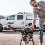
LiDAR Mapping with Drones
LiDAR mapping with drones is a revolutionary idea that’s already being used for a variety of applications around the world. The technology allows surveyors to take aerial scans and produce 3D maps of an area, using a LiDAR system on a drone. It is also known as aerial LiDAR mapping. Here, the LiDAR system is mounted on the drone.
To use a drone for LiDAR mapping, you will need to get a special lightweight LiDAR sensor for your drone. For more information, check out the best LiDAR sensors for drones.
Aerial LiDAR mapping with drones is useful for a variety of applications, including forest management, urban planning, and terrain analysis. Drones are equipped with cameras that are aimed at the Earth and flow along a predetermined automated flight path. These drones capture overlapping photos of the terrain below, as well as pull data that allows for the production of 3D maps of the area.
A LiDAR drone system can cover areas that are inaccessible or difficult to reach with more typical LiDAR applications, while still providing high-resolution data with high precision.
LiDAR Mapping for Urban Areas
LiDAR mapping is a process of collecting data on the surface of the Earth to create a 3D model of different areas. You can use this technology to easily map urban areas. This makes LiDAR mapping in invaluable tool for urban planning government programs.
Since the LiDAR system is currently most often attached to planes, there are some drawbacks. By attaching the system to a plane, the system can be further from the area it is scanning. This can cause it to miss slight details in the area. Luckily, it can also be used by self-driving cars, fleet vehicles, and drones. These systems of deployment are reducing the limitations of LiDAR mapping for urban areas.
LiDAR mapping is an important tool in transportation planning and evaluation, because it can help identify issues that may be present in the current urban area and plan for new construction.
When deployed correctly, a LiDAR survey can detect tiny details in building facades and can provide a valuable record of building conditions. This data is valuable for urban planning purposes, and can be used for a variety of purposes, like ensuring compliance with licensing regulations.
LiDAR Odometry and Mapping
LiDAR odometry and mapping is commonly known as LOAM. In this technique, two algorithms are used to offer real-time and accurate 3D maps.
LiDAR is a kind of imaging system that uses lasers to map areas in real-time. It uses two separate threads to calculate the state of a LiDAR system.
One thread computes the motion of the LiDAR between two sweeps, while the other builds a map incrementally from the point cloud. When these two threads are combined, the result is LiDAR state estimation, or LOAM.
LOAM uses LiDAR data and edge and surface points to compute pose information, to make a real-time map of an area. The odometry algorithm corrects distortion in point clouds generated via the LiDAR system.
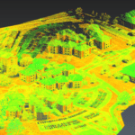
What Are Digital Elevation Models (DEMs)?
A DEM or Digital Elevation Model contains information on the ground’s surface, including vegetation and infrastructure. It is a representation of the topographic surface of the Earth. This model includes buildings, trees, or any other object on the surface of the Earth.
It can be a useful tool for engineering purposes, such as land planning and mapping. These models represent the elevation differences between known and unknown points on the surface. They are often made by interpolating information from photogrammetric data captured from aerial and ground surveys.
Digital elevation models are maps, which depict terrain features, and are typically made in a format known as a raster. Raster formats store data in grids. Each pixel represents a location on the ground, and its width is proportional to its accuracy.
What Are Digital Terrain Models (DTMs)?
A digital terrain model is a mathematical representation of the ground’s surface. Typically, it takes satellite and aerial images and applies them to a variety of applications, from navigation to surveying. Digital terrain models are created in many ways, including using digitized contours and digital surface models.
The data that goes into a DTM consists of points with known geodetic coordinates, a rule of height definition, and interpolation. LiDAR mapping technology is essential in the creation of these accurate and high-resolution digital terrain models.
The first digital terrain model was produced in 1986, and it covered large parts of the planet. These models were then used to model water flow, simulate avalanches and landslides, and plan transportation systems. They are also used to create physical raised-relief maps and geographic information systems.