LiDAR, which stands for “light detection and ranging,” is a remote sensing method that uses laser pulses to measure the distance between objects, or the distance from the LiDAR sensor itself.
It does this by targeting an object or a surface with a laser and measuring the time it takes for the reflected light to return to its receiver. The light pulses, together with other data taken using the LiDAR system, generate highly accurate, 3D information about the Earth’s surface.
LiDAR is commonly used to make high-resolution maps in disciplines as diverse as surveying, archeology, and seismology. It can also be found in consumer products like drones, robotics, smartphones, and self-driving cars.
But LiDAR is also a commonly used technology for underwater uses. When it comes to producing accurate underwater maps, LiDAR is essential. Read on to learn more about how LiDAR technology is used in underwater applications.
How Does LiDAR Work Underwater?
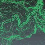
An airborne bathymetric LiDAR system works underwater by using a green wavelength of 532 nm to penetrate the water column and effectively measure the seafloor. Greenlight from LiDAR sensors can penetrate water the farthest (overcoming challenges like refraction and light absorption). Greenlight can penetrate ocean waters up to 300 meters.
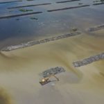
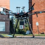
To perform bathymetry (or the underwater mapping of ocean, river, and lake floors), bathymetry survey operators need to use an airborne LiDAR bathymetric technological system. Airborne LiDAR is either mounted on a helicopter or unmanned aerial vehicle (UAV).
As soon as the airborne LiDAR device is activated, it emits laser light towards the ground in order to collect data (including seabed topographical data). The sensor returns and gives accurate data about the distance the laser had to travel to each unique point.
This scanning technique that’s used is vital in getting accurate and consistent measurements. For an airborne LiDAR device, the UAV or helicopter’s oblique flight path must be at a consistent angle to the ground, or else the results may be slightly off. The scanning technique must also be free of cross-scan voids.
Bathymetric LiDAR sensors have four main components:
- GPS receiver – this provides the aircraft’s position
- Inertial measurement unit (IMU) – this provides the roll, pitch, and yaw of the aircraft
- Laser scanner – this emits the signal in a specific pattern
- Sensor – this reads the returning signal
By understanding the orientation and position of these four main components, accurate measurements can be recorded by the airborne bathymetric LiDAR system. Some of these bathymetric LiDAR sensors can now measure more than 100,000 points per second. This results in surveys with over 10 points per m2 in shallow water.
In a recent survey delivered to the Polynesian island of Samoa, over 1.8 billion points were captured in an area of over 1,100 km2, and the deepest of these measurements achieved a depth of over 75 meters.
Modern bathymetric LiDAR sensors are divided into shallow-water systems (<10m) and deep-water systems (>10m). Shallow-water systems tend to have less laser power per pulse, a higher measurement frequency, a smaller laser footprint diameter, and a smaller receiver field of view. These systems typically only measure water depths within the visible water column.
Deep-water bathymetric LiDAR systems, in contrast, harness more laser power per pulse, have a lower measurement frequency, as well as a larger laser footprint and receiver field-of-view. These systems vary in depth penetration capability, ranging from between 2.0 to 3.0 times the Secchi depth measurement.
To maximize detail and coverage, bathymetry survey operators tend to utilize both shallow-water and deep-water sensors simultaneously in twin optical port survey aircraft.
What Happens When LiDAR Hits Water?
Missing pulses sometimes occur when the laser pulse from the LiDAR bathymetry scanner hits the water. This happens because water has a tendency to absorb most or all of the near-infrared laser energy directed towards it. Not all water does this, as laser reflection from water is affected by water surface roughness.
The presence of waves and turbidity (i.e. the cloudiness or haziness of the water) will also impact laser reflection.
For the successful penetration of pure water, you only need a wavelength of 440 nanometers (nm). The saltwater found in oceans, rivers, and some lakes, however, needs a wavelength of at least 532 nm (which is the wavelength of the color green) to ensure the LiDAR is able to penetrate the water.
Aside from getting the optimum wavelength, you also need to consider the power output. The deeper your laser penetrates underwater, the more power it loses. And for LiDAR to measure variable distances, it has to travel to and from the target points. In other words, it will lose power twice.
To ensure a successful outcome, you’ll need to increase the power. However, adding too much power can also damage the bathymetric LiDAR system. A high-power laser beam would also pose a serious threat to the people around it, blinding them if they looked directly at the laser.
Water also has a tendency to refract light—bending it at an angle and slowing it down. This means that if the water is too turbid, the signal may not reach the seabed or return.
Now that we understand LiDAR technology’s limitations, how can survey operators ensure a successful outcome for their bathymetric LiDAR surveys? Aside from turbidity, other factors need to be considered before proceeding with the survey—including the weather for flying, air traffic controls, tides, vegetation condition, and ground control accessibility.
Water clarity, or lack thereof, is a major obstacle to water penetration for bathymetric LiDAR sensors. Seagrasses and low-reflectance seafloors can also impede the success of a survey. Understanding and managing these conditions will not only determine the outcome of the survey, but will also impact the safety of all the people involved.
How Deep Can LiDAR Penetrate Underwater?
The green spectrum (532 nm) laser beam from an airborne bathymetric LiDAR system can penetrate up to 300 meters underwater.
Does iPhone LiDAR Work Underwater?
Yes, the iPhone 12 Pro and iPhone 13 Pro’s LiDAR scanners work underwater. However, they do have a limited range that they work underwater. Both models can sustain a maximum depth of six meters for up to 30 minutes. For maximum safety, you should house your iPhone in a waterproof case for maximum protection.
The iPhone’s LiDAR sensor adds depth scanning for sharper photos and an enhanced augmented reality (AR) experience. LiDAR technology bounces laser lights off objects which return to the system. It does this to measure the distance traveled by the laser light pulses.
The iPhone LiDAR scanner emits waves of light pulses in the form of multiple infrared dots. The sensor can measure each infrared dot, creating a field of points that map distances. This allows your iPhone LiDAR to gauge the dimensions of an area and the objects in it.
According to user reviews, the iPhone LiDAR scanner can get a good reading within a two-meter distance in crystal-clear water. Any further than that and the water absorbs the infrared light. As for underwater mapping, this is not yet possible with a smartphone like the iPhone since no commercial chip currently harnesses the green spectrum (532 nm) laser beam.
What Are the Different Underwater Applications of LiDAR?
Over the last few decades, LiDAR technology has been used to perform underwater mapping in coastal waters and other shallow water regions. LiDAR data has also been used to support inundation and storm surge modeling, hydrodynamic modeling, coast vulnerability analysis, and hydrographic surveying.
Here are some of the most common underwater applicants of LiDAR:
LiDAR Underwater Archaeology
With so many of the world’s shipwrecks and submerged historical sites inaccessible to marine archeologists, they’re starting to turn to bathymetric LiDAR systems to broaden their ability to research.
Bathymetric data sets have been used to locate ancient Roman and Greek vessels, as well as sunken World War II aircraft. However, highly damaged or smaller wrecks may be harder to locate, even with technical analysis of bathymetric data sets.
LiDAR Shoreline Mapping
The National Geodetic Survey (NGS) is mandated to map the United States shoreline. The data is used to determine the country’s territorial limits and is also widely used in different coastal science and management applications.
While the NGS’ primary method of mapping the national shoreline is via stereo compilation from tide-coordinated aerial photography, the agency has also begun developing LiDAR-based shoreline mapping procedures to facilitate its work.
LiDAR Underwater Mapping
Bathymetric surveys using underwater LiDAR scanners allow researchers to measure water depth, map underwater terrain, and classify submerged vegetation and habitats. They’re also used to study marine ecology, water quality, and the environmental impact of contaminant spills and hydrodynamics.
The Leica Chiroptera 4X is a bathymetric and topographic LiDAR system that can capture 140,000 points per second, as well as cover shallow water regions down to a 25-meter depth. This bathymetric LiDAR system was used to efficiently map the Cape John peninsula in Canada and the Tonga archipelago in the Pacific.
LiDAR Inundation & Storm Surge Modeling
Coastal flooding from storm-surge events and sea-level rise is a major issue in many parts of the world. With global warming projected to increase these threats, it’s more important than ever for technologies like LiDAR to be used in inundation and storm surge modeling.
Maps of flood depth could be generated for all water levels and used for socioeconomic and ecosystem impact assessment.
LiDAR Hydrodynamic Modeling
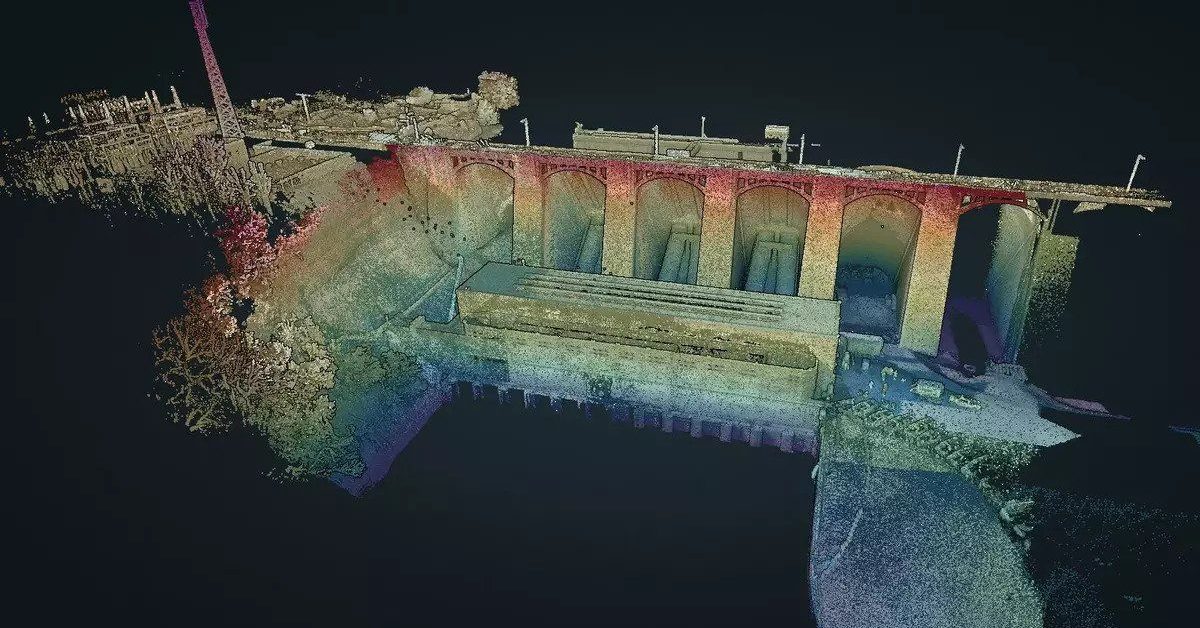
LiDAR technology is used in flood modeling to determine topography, ground cover, surface roughness, and channel networks. It’s also used to map man-made structures, like levees and bridges.
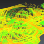
For hydrodynamic modeling purposes, LiDAR scans are converted into digital elevation models (DEMs) of the topography and may be used for roughness mapping.
While these DEMs can be resampled at different resolutions to evaluate the effects of various grid cell sizes on flood simulations, there is little information on the minimum resolution of raw LiDAR to supply sufficient information for accurate flood mapping at the given cell sizes.
LiDAR Coast Vulnerability Analysis
LiDAR’s ability to map land and seafloor elevation has allowed organizations, like the Coastal and Marine Hazards and Resources Program (CMHRP), to improve vulnerability assessments of coastal regions. The CMHRP has used such elevation data to assess the rate of change in coastal beaches, sand dunes, and coral reefs after storms and other natural events.
LiDAR data was applied to coastal vulnerability analysis in response to Hurricane Sandy, which greatly affected the coastline of New Jersey in 2012. By including LiDAR data collected before the storm in its analysis, the CMHRP was able to initialize coastal hazard models, predict coastal change, and document actual changes due to storms and other events.
LiDAR Hydrographic Surveying
Hydrographic surveying is the science of measuring and describing features that affect maritime navigation, marine construction, dredging, and similar activities. LiDAR equipment can be used to scan and map out these features using equipment like autonomous underwater vehicles (AUVs), inflatable crafts, and remote operated vehicles.
LiDAR Marsh Creation Projects
LiDAR technology is being increasingly used to map various features in coastal habitats, including salt marshes. Digital surface models (DSMs) and digital elevation models (DEMs) taken from LiDAR data have been used to map features in salt marshes and other wetlands. Many of these were done in conjunction with multi/hyperspectral imagery.
Salt marshes provide a range of ecosystem benefits, and their gradual disappearance from coastal environments is posing significant threats. LiDAR scanning and mapping is helping conservators preserve more salt marshes by identifying the upper boundaries where marsh vegetation transitions into upland vegetation.
LiDAR Disaster Response
The use of LiDAR technology in disaster response is gaining traction since visualization of the point cloud data enables emergency responders to easily identify areas most affected by calamities.
The growing accessibility of LiDAR data is helping government agencies evolve the way that they get ready and react to disasters. Access to LiDAR point clouds helps reduce the amount of time it takes to get dependable data about the situation of natural disasters.
The visualization of the LiDAR point cloud allows emergency responders to easily identify areas that were most affected by the disaster. In some cases, having a three-dimensional view of the disaster situation can provide unique information that helps responders rescue victims more quickly.