LiDAR is a sought-after remote sensing technology for detecting distant objects and measuring distance.
In this technology, the laser beam is emitted, and a sensor is used to collect scattered beams to capture 3D information of a scanned object. LiDAR works much like sonar and radar but uses a laser beam instead of sound or radio waves.
It is an extremely fast and accurate source of direct data. The sensors used are designed to detect movement and reflect the light back into the sensor. It can be used to map objects, areas, and topographical features and is ideal for hard-to-reach areas.
This technology is used in various surveying and mapping applications, such as Architectural. Engineering, Construction, Industrial, and Transportation. To know more about LiDAR and its uses, continue reading this article.
What Does LiDAR Stand For?
LiDAR stands for Light Detection and Ranging. As demonstrated by the name, the technology uses “Light/ Laser” to “Detect” and measure “Ranges” of various targets and objects.
LiDAR uses laser technology to map areas. The system sends pulses of laser light to a target and measures how many times they return. The laser is then used to map site features, such as buildings, roads, pavement striping, vegetation, and any number of other site features.
Who Invented LiDAR?
The idea of LiDAR was first invented in the year 1930 by EH Synge. However, it was Hughes Aircraft Company that first introduced LiDAR as we know it today, in 1961.
Shortly after the invention of laser technology, this aircraft company developed LiDAR like a system for satellite tracking under the guidance of Malcolm Stitch. Originally named “Colidar,” the system used laser-focused imaging to calculate the distance.
What Are the Types of LiDAR?
There are two basic types of LiDAR systems in the survey and mapping industry based on functionality, airborne LiDAR & terrestrial LiDAR. Terrestrial LiDAR systems are mounted on a vehicle or on a tripod on the ground surface, whereas airborne LiDAR is mounted on a helicopter or an Unmanned Aerial Vehicle (UAV).
-
What is Airborne LiDAR?
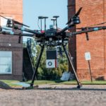
Airborne LiDAR is a form of remote sensing that has many applications in the military, scientific fields, and the survey and mapping field. This type of LiDAR system is installed on a UAV or a conventional aircraft, such as a helicopter. What platform is selected for the mapping exercise is dependent on many things, such as project size, project accessibility, and project cost and schedule constraints. As soon as the device is activated, it emits light towards the ground for collecting data.
The sensor returns immediately and gives accurate data about the distance the laser traveled to each unique point. The scanning technique is the key to accurate and consistent measurements. For airborne LiDAR, the plane’s oblique flight path must be a constant angle to the ground. In addition, the scanning technique must avoid the risk of cross-scan voids.
The primary advantages of UAV-based airborne LiDAR over traditional aerial mapping are its ease of use, high accuracy, and low cost. Airborne LiDAR systems can be further divided into bathymetric LiDAR and topological LiDAR.
-
How can Terrestrial LiDAR help with land surveying?
A Terrestrial LiDAR is a type of ground-based laser scanning system. This type of device produces highly accurate 3D data. It is a great solution for projects with small areas that require precise measurements and detailed information.
Moreover, a small team of surveying teams can use a lightweight tripod-based scanner to map industrial facilities, infrastructure, town centers, and smaller areas. Here, the system is installed on tripods or vehicles. It works by capturing high-resolution point clouds of objects. These point clouds are extremely accurate, allowing you to use the data for a variety of purposes. This technology is extremely versatile, allowing for CAD and other imaging applications. Terrestrial LiDAR systems can be further divided into static LiDAR and mobile LiDAR.
How Does LiDAR Work?
LiDAR follows the simple principle of throwing a laser beam at an object and measuring the time the light beam takes to return to the receiver. There is a laser source at the system that fires rapid laser pulses and a receiver sensor that calculates the amount of time the light takes to reach back. A rapid succession of these events allows the system to determine the speed and distance of the target. Here is a formula that analysts use to get the precise distance.
Distance of the object = (Time of Flight x Speed of Light) / 2
What Is LiDAR Used For?
LiDAR is an optical technology that measures the time it takes a laser pulse to travel. This system is widely used for land surveying, power line inspection, transportation expansion, mining applications, forestry and farming, making high-resolution maps, etc.
LiDAR can also be used for autonomous cars, oceanography, agriculture and archeology, space travel, and of course survey and mapping. Scientists also use LiDAR in construction to measure spaces and build 3D models. It’s also used in place of radar in law enforcement. Here are some applications of LiDAR.
-
How can LiDAR technology be used for Mapping?
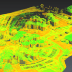
LiDAR technology is a powerful tool for mapping and identifying objects in real-time. Using a laser, LiDAR can accurately measure distance, material properties, and optical characteristics. Its reflected beams collect data in three dimensions, enabling the collection of highly accurate maps.
This technology has many advantages over other surveying technologies, including radar and sonar, and it has the potential to revolutionize mapping. While sonar and radar struggle with movement and plotting the exact location of an object, LIDAR is able to capture these features and make them easily understandable. LiDAR technology can be used to map the surface of any city or area.
-
How can LiDAR data benefit the Architecture industry?
The use of LiDAR in architecture is becoming more common. This technology can be used to create accurate 3D models of existing buildings, known as Building Information Models (BIM). The data can be assessed against building regulations and health and safety guidelines.
This data is invaluable for architects, designers, and engineers. They can make better plans and prevent mistakes before they even occur. With proper planning and preparation, LiDAR can help you plan and design new buildings and renovate old ones. The data collected by the LiDAR system can be used for planning new buildings and renovations or to re-design existing buildings to comply with regulations.
-
Can LiDAR help reduce Construction costs?
During construction projects, LiDAR can be utilized to inspect the stages of a project. These scans allow for quality assurance and the detection of errors before they become major problems. For instance, LiDAR can be used to evaluate prefabricated materials. Using LiDAR technology in construction can reduce costs, improve efficiency, and push the limits of architectural design.
The benefits of using LiDAR in construction are clear. It cuts down on rework and costs. When used properly, it can be an extremely effective tool for ensuring that a building is independent of its surroundings. It’s also possible to use LIDAR to identify faults in a structure.
-
How can LiDAR help the Environment?
Environmental mapping is an important tool for the conservation of natural resources. LiDAR data can help geologists study the Earth’s topology by mapping the terrain. The technology can detect subtle topographic features of a landscape. It can map river channels, terraces, and soil uplift.
This information can help land managers plan, implement, and improve the quality of their land. In addition to mapping the environment, LiDAR technology is useful in agriculture. It can determine the roughness of different soils and make decisions about crop planting and tillage. The use of LiDAR for environmental studies is increasingly being used to help manage climate change.
-
How is LiDAR technology used in the Automotive industry?
Today, automakers are integrating LiDAR technology into their advanced driver assistance systems to better understand their environment and make better decisions. The new technology can capture and interpret millions of points of data every second, allowing ADAS systems to make hundreds of decisions per second.
LiDAR is a type of sensor technology. It is a form of laser that captures light and translates it into a 3D representation. This information helps cars navigate more safely and accurately, thereby reducing accidents.
-
How can LiDAR scanning be used in Real Estate?
The development of new technologies is revolutionizing the real estate industry. The use of 3D scanning is becoming more common as homes are better documented. Moreover, LiDAR technology allows for unprecedented detail in existing buildings at a specific point in time.
The use of LiDAR technology in real estate involves the use of sensors to capture the small details of a building’s facade. It helps to measure indoor space and create floorplans.
-
Has LiDAR technology ever been used in Space Exploration?
Despite its potential for space exploration, LiDAR has been used for a variety of other applications, including meteorology and astronomy. In 1999, NASA launched the ICESat mission to study the moon’s topography and return data about its location and size.
The Phoenix Lander used LiDAR to measure how much snow falls on the planet, and it is also being used by NASA to study clouds and aerosols on Earth. The Mars Meteorological LiDAR mission uses LiDAR to provide data about fog, cloud, and dust plume conditions on Mars.
-
How can LiDAR be used for Gaming & Augmented Reality?
The LiDAR creates a three-dimensional map of the environment, allowing developers to place virtual objects onto the real world. This technology also has applications in gaming and automotive.
LiDAR is a technology that uses light pulses to bounce off objects, including people and animals. This technology creates a 3D map by mapping objects and spaces in a virtual environment. It can be used to develop simulation racing games.
-
Can LiDAR be used to create Digital Elevation Models?
A digital elevation model is a representation of the Earth’s surface using points and a chosen coordinate system. A DEM is obtained through ground topographic surveys, airborne optical sensing of bathymetry, mapping techniques, and more. A liDAR is an important tool in creating a Digital Elevation Model.
-
Can LiDAR be used to create Digital Terrain Models?
LiDAR can also be used in a form of aerial photography that is a great help in the creation of digital terrain models. It is an excellent tool for mapping large areas and is particularly useful in areas with high-velocity traffic, such as cities.
The accuracy of LiDAR measurements makes it a valuable asset for assessment, modeling, and analysis purposes.