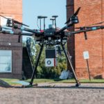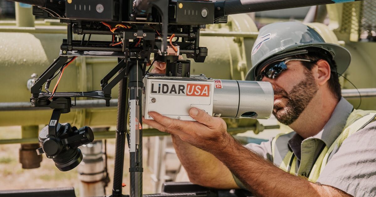
Cameras and sensors for drones have brought a revolution to the surveying and mapping industry. They’re used for capturing imagery and providing highly accurate results.
Gone are the days where you need large aircraft or large LiDAR sensors to map areas. Instead, you can use compact drones equipped with compact LiDAR sensors to collect data at higher accuracy. LiDAR cameras can easily be mounted on UAVs to capture information with a high resolution.
Aerial LiDAR sensors can see through ground cover, making them indispensable for urban surveys. This technology also works in darkness, allowing it to see through objects in the ground and overgrown areas of farmland or shallow water.
Many companies manufacture LiDAR sensors for drones. The biggest are Velodyne, LeddarTech, Routescene, YellowScan, Riegl, Leica, and Geodetics.
If you are looking for a LiDAR sensor for your drone, we can help you. Through this article, we are going to discuss the best LiDAR sensors for drones (UAVs).
How Much is a LiDAR Sensor for a Drone?
The cost of a LiDAR sensor has a large range. They are anywhere from a few hundred dollars to tens of thousands of dollars. It depends entirely on the size, type, and functionality of the LiDAR sensor you need. LiDAR technology used to be inaccessible for many businesses, with the only options being in the tens of thousands of dollars in terms of price.
But with the increase in the amount of LiDAR manufacturers, there are LiDAR sensors you can buy for just a few hundred dollars.
The up-front cost of a LiDAR sensor can make it difficult for companies to invest in a LiDAR camera for a drone. Depending on your LiDAR needs, purchasing an entry-level commercial LiDAR system for your drone can cost up to $23,000.
There are also additional costs for accessories like batteries, GPS rover, base station, etc. You’ll also need to get equipment insurance for the LiDAR sensor. For reference, on a $23,000 LiDAR sensor, equipment insurance will cost approximately $2000 annually.
If you don’t want to invest that much for a LiDAR sensor, there are also more affordable, yet high-quality sensors from Velodyne available for around $4,000. Another option is to rent a LiDAR drone for approximately $1,400 per month.
And if you just need a cheap LiDAR sensor, LeddarOne has options for as low as $110.
How Do I Choose a LiDAR Sensor?
If you’re thinking about purchasing a LiDAR sensor for your drone, you’ve come to the right place. These devices produce high-resolution maps and 3D models of man-made and natural objects. However, this can be a big decision, and you need to consider some very important factors to choose the best one for you.
-
Flight Altitude
When selecting the right LiDAR sensor for your aerial vehicle, the flying height should be taken into consideration. There are many types of LiDAR sensors available, and it is important to know how the different types work. Flight altitude affects the density of the point cloud, which will affect your decision on which sensor to buy.
Different use cases may require different point cloud densities. Tactical-range sensors are perfect for flying below 60m AGL. If the height is more than 60m, you need to choose a long-range or mid-range LiDAR sensor.
-
Resolution
You also need to consider the resolution of the LiDAR sensor, which determines the density of the point cloud that the LiDAR sensor produces. Mid-range/tactical LiDAR sensors offer 5cm-10cm @ 30m resolution, whereas long-range sensors offer about 2m-3m @ 100m. This means that the model will have a density of 5-10 cm at 30 meters distance.
You should carefully consider flight altitude and speed before selecting your sensor.
-
2D vs. 3D
When buying a LiDAR sensor, you’ll also need to pick between 2D and 3D. While the two types of LiDAR sensors share many similarities, there are also some significant differences. You’ll need to decide if 3D or 2D is the right decision for you based on the application of the LiDAR sensor.
The difference between the two is that a 2D LiDAR sensor only casts one beam, while a 3D LiDAR sensor casts multiple beams of light at the same time, to collect more data faster.
-
Range and Accuracy
Another thing you need to consider when buying LiDAR sensors for drones is accuracy and range. There are different types of LiDAR sensors available in the market, and they all offer different ranges and accuracies. So, you should make sure you compare the sensors and choose the one that offers the accuracy and range that suits your needs.
-
Number of Channels
When buying a LiDAR sensor, another thing to keep in mind is the number of channels. Typically, LiDAR sensors with a higher number of channels will offer a detailed and denser point cloud. So, the more channels that the LiDAR sensor has, the greater the accuracy of the LiDAR sensor.
-
Points Per Second
Another factor when buying a LiDAR sensor is its points per second (PPS). This measure is an important parameter to look for. This references the number of laser measurements made per second. More points indicate a more detailed and accurate point cloud.
-
Size and Dimensions
Another thing you need to consider is the size and dimensions of the LiDAR sensor. The shape and size of the LiDAR system will affect the mounting capability. If you’re hoping to use the LiDAR system on a drone, then you need to choose a sensor that is compact and lightweight. That way you’ll be able to easily mount the system on a drone.
-
Price
Since these systems can be quite expensive, you need to go with a sensor that fits your budget. The best thing you can do is compare the different sensors available, and choose the one that offers the features you need at an affordable price. Later in this article, we’ll go over some of the best LiDAR cameras for drones.
How do LiDAR Sensors Work?
Essentially, LIDAR sensors use a laser pulse to detect objects and create detailed 3D maps. These sensors emit laser pulses towards an object or an area. The laser pulse is then refracted back after it bounces off of the object.
These scattered light signals are then recorded by a laser scanner inside the LiDAR sensor. It is also equipped with a navigation and positioning system to measure the distance from the LiDAR sensor to the object, i.e. (time of flight x speed of light).
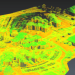
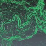
After measuring the distance, the plane position and altitude are used to compute the precise echo position of the objects in the area. Computing technology in the LiDAR system process the images and create a highly-detailed 3D map of the surrounding.
Here is a simple explanation of how LiDAR sensors work.
- Step 1: Emission of laser pulse
- Step 2: Recording the refracted light signal
- Step 3: Measurement of distance (time of flight x speed of light)
- Step 4: Getting data about altitude and plane position
- Step 5: Computing accurate echo position via 3D maps
What Can You Do With a LiDAR Drone?
LiDAR drones are capable of producing 2D and 3D maps instantly with higher accuracy. Because of this reason, many companies are using LiDAR drones to easily map large areas. Here are some of the most common uses of LiDAR drones.
-
Accident Scenes
There are several ways first responders can use LiDAR at an accident scene. They must preserve the accident scene and collect evidence by reconstructing the event, so LiDAR drones can be used to easily map the scene and provide an accurate 3D representation. And since data has shown that the longer a road is closed due to an accident, the greater the risk of a secondary accident. In this way, drones can reduce the risk of accidents, and even save lives!
-
Archaeology
Drones are also great for use on archaeological sites. The use of drones saves time and money by detecting areas that may be archaeologically significant, without having to spend hours combing through the site. Drones can be useful to detect artifacts that are hidden by sandstone, and the remains of animals and plants in archaeological zones.
-
Agriculture
The use of LiDAR technology in drones can improve agricultural productivity and yields by revealing a variety of details that are otherwise impossible to see. While a farm may look like an open, flat expanse, the land can have undisclosed slopes, differences in soil, and other features that affect crop yields and costs.
LiDAR technology allows farmers to make better decisions about which crops to plant, and where to plant them. This is because farmers can use LiDAR to inspect and identify their soi, which affects where and what to plant.
-
Conservation
The use of LiDAR-equipped drones in conservation projects has many different applications. For example, you can use LiDAR to map forests which will help protect and conserve the forest. It can also be used for mapping flood plains, to aid in conserving water. This also applies to mapping and conserving sand dunes.
-
Insurance
The use of LiDAR drones in insurance is a revolutionary new method of assessing damage to buildings. In the past, insurance adjusters had to manually inspect buildings for damage and changes.
Now, LiDAR drones can map entire urban areas in a matter of minutes, providing a highly accurate representation of the area in question, and any potential damage. This is why LiDAR drones have begun replacing manual roof inspections.
-
Inspections
LiDAR drones can also be used in inspections. For example, if a utility company wants to inspect a power line, LiDAR drones with LIDAR sensors can eliminate the need to “eyeball” inspection.
Rather than having workers manually look to see if the line is damaged, or guess if a tree is too close, LiDAR sensors can be used. A LiDAR drone can gather and determine this information without the possibility of human error.
-
Search & Rescue
LiDAR sensors serve a variety of purposes for search and rescue teams. Drones that are equipped with LiDAR can be used to locate survivors and wreckage in flooded areas. This is especially helpful in areas with difficult access, like the mountains.
-
Forestry
Aerial forestry mapping with LiDAR can help companies and governments to understand how to manage their forests. Tree inventories require the accurate measurement of trees, including the size and location of individual trees.
LiDAR drones can help with this, since they provide a precise, high-resolution point cloud dataset of the forest environment, even in environments with poor lighting conditions.
-
Mining
Using LiDAR drones for mining projects can save time, money, and even lives. The drones can gather information about an area, like its geological features. The data from these drones can be visualized and analyzed in order to help mine operators plan their operations better.
-
Terrain Modeling & Mapping
A LiDAR drone can be used to survey terrain and develop models of the topography of an area of land. LiDAR drones have unique capabilities that allow them to perform various terrain modeling tasks, such as assessing the vegetation of an area.
-
Irrigation
The use of LiDAR-equipped drones in irrigation can save farmers considerable money in irrigational misuse. In addition to determining the distance between distant objects, LiDAR can also be used to provide an excellent 3D model of certain terrains, like a farmer’s fields.
This model can then be used to provide the farmer with critical information on how best to build, modify, and use their irrigation system.
Leddartech Vu8
LeddarOne is another LiDAR sensor you can use with a drone. It’s a full-beam sensor that helps in single-point measurement, allowing you to detect the proximity of an object to its beam. In the LeddarOne, a photodetector and LEDs are combined in a single module with an MCU. One benefit of the LeddarOne is that the device interface is made of a waterproof housing.
LeddarOne is ideal for detecting small objects that may not be seen through normal sight. You can easily integrate it into any drone system, due to its lightweight and small footprint. This sensor module offers a wide range of applications, low power consumption, and excellent accuracy. It can be used in security, level sensing, drone altimetry, and more. The sensor offers excellent range, proximity detection, and a conic beam.
- Range: 0 to 40 meters
- Weight: 14 grams
- Refresh Rate: 140Hz
Velodyne LiDAR Sensors
Velodyne is one of the biggest LiDAR sensor manufacturers in the world. They have four of the best LiDAR cameras for drones. Velodyne sensors collect data reliably in a variety of conditions, including low-light situations and poor weather. Here are 4 of the LiDAR sensors offered by Velodyne.
-
HDL-32E LiDAR Sensor
The HDL-32E LiDAR sensor by Velodyne is a rugged, stylish, and reliable sensor for a wide variety of industrial applications. Its unique multi-channel array provides an unprecedented field of view, allowing the HDL-32E to provide high-definition 3D information. Designed to meet real-world industrial demands, the HDL-32E is suited for applications in autonomous vehicle control, mobile terrestrial mapping, aerial 3D mapping, security surveillance, and more.
The HDL-32E LiDAR sensor is a miniature device with 32 channels, which allows the sensor an incredible vertical field of vision. The HDL-32E is approximately 5.7″ high x 3.4″ in diameter and weighs less than two kilograms. The HDL-32E Lidar Sensor is designed for real-world applications in autonomous navigation and is currently being used for 3D mobile mapping.
- Range: 80 – 100 meters
- Weight: 1.3 kg
- Number of Channels: 32
- Points per Second: 700,000
-
Puck VLP-16 LiDAR Sensor
The Puck VLP-16 Lidar sensor is a 16-channel sensor that was released in 2014. It was priced at $8,000 at the time of its release but is now available for less than $4,000. Its mainboard contains RF components, switches, and receivers from Texas Instruments, and it comes with 8 MB of flash memory. This sensor is also CE-marked, giving users peace of mind that it’s safe to use.
- Range: 100 meter
- Weight: 830 grams
- Number of Channels: 16
- Points per Second: 300,000
-
Puck Lite LiDAR Sensor for UAVs
The Puck Lite is another lightweight LiDAR sensor from Velodyne. It is the lighter version of the Puck VLP-16. This sensor delivers the same performance as the former model with the main difference being its weight. It weighs only 590 grams, compared to the 830 grams of the VLP-16.
Other than that, the Puck Lite is very similar to the VLP-16. It offers the same patented 360-degree surround view, which makes it perfect for UAVs like a drone. The Puck Lite is ideal for UAVs or backpacks, as it is compact, but still delivers great performance and resolution.
- Range: 100 meter
- Weight: 590 grams
- Number of Channels: 16
- Points per Second: 300,000
-
Puck Hi-Res LiDAR Sensor for UAVs
The Puck Hi-Res is another lightweight and compact LiDAR sensor that can be mounted on a drone or other aerial vehicle. This sensor offers an even greater resolution, while maintaining the range of 100 meters like the original Puck. The Puck Hi-Res is able to take measurements at a greater distance because its 16 channels are grouped closer together. This means that the high-resolution image that you get is better for object recognition.
The Puck Hi-Res sensor is a recently released sensor by Velodyne LiDAR. This sensor is intended to provide higher image resolution for aerial mapping, allowing for a more accurate map.
- Range: 100 meter
- Weight: 590 grams
- Points per Second: 300,000