Land use mapping is a method of analyzing land use patterns with the help of remote sensing technology like LiDAR and radar.
You can use these technologies to create detailed maps and see the changes in the land’s use over a period of time. For example, it can show how much of a particular area is forest. It can also show how much of it is used for agriculture, wetlands, or open water.
Typically, land use maps are created from topographic maps, land allocation plans, aerial photos, and statistical data. These types of maps can be used to monitor development trends, identify urban land-use patterns, and identify potential issues associated with inefficient land use. For example, a land use map could show the degradation of a natural resource in an area.
Land use is changing at a rapid rate, and high-resolution maps are essential for decision-makers in a variety of economic industries and government bodies. Land use maps improve understanding of important topics, such as land conservation and planning.
National governments use maps to identify trends and determine land planning priorities and budget allocations. And they’re increasingly useful for planning future development.
What is Land Use Mapping For?
Land use mapping is the process of identifying an area of land’s use. It includes the classification of different types of land as well as the distribution and use of the land geospatially within a region. This allows for the delineation of existing uses which often includes data such as zoning, rivers, streams, creeks, bayous, roadways, available utilities and other attributes of the property.
These attributes can then be used by government agencies and private developers to work in concert to prepare long term land use plans for geographic regions. These plans utilize land mapping to identify appropriate locations for various zoning uses, regional detention areas, wetland mitigation banks, conservation areas, roadway corridor planning, school zoning, etc. some of these are detailed in further in the following sections:
Stormwater Runoff Prediction
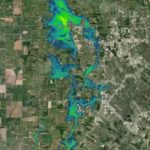
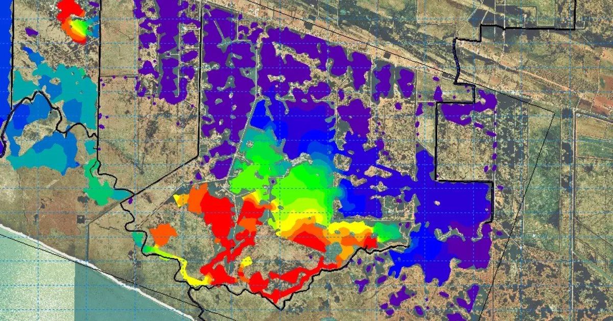
Stormwater runoff can carry harmful pollutants which, if left untreated, can pollute rivers, lakes, and oceans. To prevent this, it’s important to predict stormwater runoff and drainage quality and quantity. This is where land use mapping comes into the picture.
The U.S. Department of Interior, the U.S. Geological Survey, and many other organizations have supported an effort to produce a high-resolution map of the landscape around water utilities and wastewater treatment facilities.
These maps would provide precise spatial information about the various land uses in the area and would allow for detailed analysis and correlation of runoff data from land uses to stormwater management and control.
This program helps to predict the volume of runoff that will occur in different locations. It’s designed for site developers, urban planners, landscape architects, and homeowners interested in understanding how stormwater management would affect the characteristics of their watersheds and mitigate flooding. While it’s not a perfect tool, it can help you to plan more effective stormwater management strategies and minimize the impact of runoff on the environment.
Land Development
Land development is one of the most popular investment opportunities today, and for a good reason. When a developer decides to invest in land, they have to do their due diligence and assess the land properly, as well as file the appropriate applications for all required permits.
However, to do that, it is important to map the land use first. A good land use map will reveal the patterns of land use, such as road networks, housing availability, and industrial and commercial space.
An extensive database of geospatial information is available for the application of land use mapping in land development. Land use maps can be classified according to their use, such as industrial, residential, and recreational.
These maps are essential for land development as it helps to identify potential markets as well as understand the impact the project will have on the land.
Today, many businesses and governments are using land-use mapping for land development purposes. The process of land use mapping helps developers and policymakers identify and mitigate potential problems that might arise due to development.
Urban Planning
City planners use very specific processes to plan cities and neighborhoods. Often, they look five or twenty years ahead to determine the effect of current trends and activities. They may even look fifty years ahead to plan for environmental issues.
City planning also involves determining what the city’s needs and resources will be. There are several types of urban planning, including transportation, housing, and environmental planning. To plan for all of these factors, land use maps are incredibly helpful.
For more than 20 years, the World Resources Institute has been developing methods and infrastructure for the application of land use mapping in urban planning. These maps provide cities with a powerful tool for improving the quality of life of their citizens.
In urban planning, land use mapping is a key tool for assessing a city’s future growth. It helps local and regional governments plan for the future of their area. It guides their actions and promotes the efficiency of operations. The information gathered by land use mapping can also help municipalities make better decisions for the future.
Water Use Calculations
Potable water use calculations can help authorities determine how much water is needed in a particular land area. It is important to know the potable water requirements to make sure that there is enough water available for the needs in that area. These include fighting fires, street cleaning, and more.
It also helps to prevent the wastage of water and water pollution. In order to calculate water use requirements, cities will use land use mapping.
This method involves using satellite imagery to determine the area covered by a given layer. By assessing the extent of various land-use types and development trends, water use calculations can be made with more accurate results.
If this data is used correctly, it can help decision makers implement policies with the aim to reduce human-induced water pollution in water resources.
Conservation Planning
Conservation planning is an important part of environmental science. It is the process of creating steps that a company or group will use to conserve natural resources and protect the environment.
Accurate maps can help determine how land is used for conservation planning. For example, scientists study land cover changes and the effects of human population expansion and climate change.
Using technologies like LiDAR can speed up this process, allowing scientists to spend less time creating maps, and more time working on conservation planning.
Using a map for conservation planning is a good way to ensure that decisions are based on scientific evidence. Without considering scientific evidence, businesses and governments are much more likely to make inefficient decisions.
The usage of land use mapping in conservation planning is often facilitated by the inclusion of biodiversity indicators. These indicators can be used to quantify the effects of development. They are typically associated with the extent of habitat fragmentation and include aspects of landscape ecology, conservation biology, and land use planning.
Habitat Restoration
Habitat restoration is the process of restoring a particular ecosystem, particularly in the form of a natural landscape. Restoration projects involve restoring ecosystems to their pre-civilization state.
The key to a successful restoration project is public understanding. People should always be aware how land looked like before the introduction of modern civilization, and how they affect the environment.
Land use maps can help us understand the current state of different habitats. We can use them to learn more about the soil and terrain of an area, which offers insights into whether or not different species would survive in an area.
We can also see the extent to which a certain habitat has been altered or lost. Conservation targets that consider the extent of habitat loss and restoration can help mitigate the problem of overly slow, gradual efforts.
By studying land use maps, habitat restoration groups can determine and rank areas by the severity of habitat destruction, to figure out which areas need attention first. This can help mitigate the negative effects of habitat destruction, by reversing the issues in the areas that are most heavily affected first.
Natural Resource Management
Natural resource management is a way to protect and conserve natural resources, especially those with high conservation values. It encompasses economic, social, and environmental values and incorporates community and industry input in planning and decision-making processes.
Land use mapping is a critical component of natural resource management. Land-use changes over time, and integrating information from various sources is crucial for sustainable management.
In natural resource management, land use maps can help managers make informed decisions about the most sustainable ways to manage the resources in a given area. They can help managers understand the factors affecting resource utilization and ensure the resources are used wisely.
By utilizing land use maps to make smart decisions, they can ensure that the natural resources they manage are being used sustainably and efficiently, especially for future generations.
Tax & Property Evaluations
Land use mapping also helps to evaluate tax and property value. One way that land use mapping helps in the process of tax & property evaluation is in the assessment of the value of land or property. Baseline mapping and subsequent monitoring are critical to evaluating the value of a piece of land.
The primary function of a tax map is to identify the boundaries of individual properties in relation to those of neighboring real estate. It also helps in the development of land value maps.
Tax maps reflect the shape and size of parcels within an assessing unit and are a primary backup for assessment rolls. These maps can provide data on land values, property values, tax revenues, ownership, and other relevant information.
Land Use Vs Land Cover
The term land use is often used interchangeably with land cover. However, they are not the same. There is a significant difference between the two terms. The distinction between land cover and land use can make a world of difference.
In simple terms, land cover describes the physical properties of the Earth’s surface. It could be forest, desert, water, or a built-up urban area. Land use, on the other hand, lays out how humans have shaped and used the land. Land cover may change naturally, whereas land use is a result of human action.
Land cover mapping is crucial for resource management, research, and ecological planning activities. These maps are created to compare the surface of the Earth after different intervals of time. For example, land cover mapping can be used to identify the decline in forests, and the changes in the ice glaciers.
Land cover maps are also useful for planning and management purposes, since they show the current condition of the land. This includes the amount of forest, wetlands, levels of water, and more in an area.
On the other hand, land use focuses on the purpose of the land. It gives you an idea of how humans have used an area of land, rather than simply mapping the surface area. Land use mapping can also help you monitor the changes in land use over time.
It is important to distinguish between the two when it comes to mapping. While the technology used to create a land cover and land use maps can be the same, land use mapping requires high-tech software to interpret the map and identify how it’s being used.
Both of these techniques of land mapping are used to inform important decisions and policies regarding the use and conservation of land. They are 2 techniques that each work well on their own but are a great combination when combined. They allow us to study the natural change of land, as well as the impact humans are having on it.